Have You Got Your FAA WINGS?

Have You Got Your FAA WINGS?

0 Comments

The FAA started their Pilot Proficiency Award Program (commonly known as FAA WINGS) in 1996.  It is run by the FAA Safety Team, or the FAASTeam.  The intent of the program was, and is, to “improve the nation’s accident rate by conveying safety principles and practices through training, outreach, and education” (taken from faasafety.gov).  The FAA WINGS program, free of charge, encourages pilots to pursue recurrent training to enhance their overall knowledge of all the aspects of aviation.

FAASTeam Logo FAA WINGS

The FAA WINGS program has evolved over the years, but with the current structure, pilot’s accomplish tasks, both knowledge and flying, for credit that adds up to the equivalent of a flight review.  Pilot’s must accrue three knowledge credits and three flight credits to complete a phase, and each phase acts as a flight review.

FAA WINGS has three levels, the basic, advanced, and master level.  Under each level, you accomplish different phases.  The basic level is “designed for pilot’s [desiring] a higher level of proficiency than … a normal flight review” (faasafety.gov).  The flying tasks in the basic phase are based on the private or commercial pilot PTS, depending on the airman’s certificate level.  The knowledge courses revolve around many different areas, all of which can be viewed on the FAASafety Team’s website.    Most are free, but there are some courses that have a cost associated with them.  In the advanced and master phases of the FAA WINGS program, the tasks have higher standards, challenging pilots to hold themselves to those higher standards.

One unique aspect of the FAA WINGS program is the opportunity to attend a safety seminar for credit. Throughout the year, there are many different safety seminars that take place in the different FSDO areas. The FAA WINGS seminars range from a study of accidents, to GPS usage and anything in between.  You can even get FAA WINGS credit for attending the Bonanza BPPP or the Cirrus CPPP programs.

As an instructor, I highly recommend to all my customers to enroll in the FAA WINGS program and use it. This keeps pilot proficiency at a high level, which in turn keeps safety at a high level as well.  Plus, you get to learn a lot too!

If you’d like to enroll in the FAA WINGS program, visit faasafety.gov to create an account.  Then, find a good instructor and start working on those phases!

Weather Avoidance

0 Comments

I began flying a Piper Malibu earlier this year.  For those of you not familiar with the original PA-46, a Malibu has a Continental TSIO-320 engine, with 310 HP.  It’s pressurized and cruises at about 185-200 KTAS.

A few things are introduced to the equation when pilots start flying higher, faster, and farther.  When you start flying over longer distances, weather becomes more of an issue.  On a quick hop from, say, Austin to Dallas, you can be pretty sure of what the weather will be since it’s a short trip.  When you fly from Austin to LA, leave in the morning, land once along the way, and arrive in the afternoon after spending six and a half hours in the air, weather can change a lot in that amount of time.

A must for any pilot flying high and over long distances is some kind of Nexrad system, whether it be a Garmin 696, or it shows up on your GPS or MFD.  Having this situation awareness is very helpful when planning ahead as to what to do about weather.  A stormscope is also a handy tool, since you can see where the lightning is with it.

Cold fronts can be pretty nasty, depending on how strong and how fast they are moving.  A strong, fast moving cold front usually has a lot of convective activity associated with it.  The tricky thing with storms associated with fronts is that storms form in lines, most of the time.  If you’re trying to cross a front in the morning, you can usually get high enough over the clouds with a pressurized airplane since the temperature is still relatively low to get clear of the cumulonimbus clouds.  The cloud tops will only be around ten or twelve thousand feet.

CB CloudCrossing fronts in the afternoon when daytime heating is pushing the tops of the CBs up to the 20-40 thousand foot range, it’s best to land, have a meal, stretch your legs, and wait till the sun starts to go down before pushing on.  Do not, under any circumstances, try and go through the cumulonimbus clouds associated with a cold front in a small airplane.  Not only is it uncomfortable (the turbulence bounces you around pretty good), but you’ll get ice, scare the passengers, and, if you’re in the heart of a storm, the plane could come apart.

When crossing mountains, the weather is always highly unpredictable.  If it’s a clear day, no matter your altitude, you’ll probably pick up some turbulence from all the rising air off the peaks.  If there is moisture in the air, there are going to be isolated to scattered thunderstorms in the summer time.  The advantage of flying high when there are isolated or scattered storms is you can utilize the see and avoid method.

See and avoid is simple.  When the storms aren’t embedded in other clouds, it’s actually rather easy to spot the big, rising clouds and go around them.  The same concept holds true when avoiding those pesky pop up thunderstorms in humid areas like Houston and Florida.

Rain Shafts
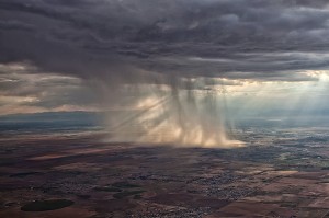
One thing that I learned this summer was this.  Sometimes, with an area of closely grouped storms, the cloud base is actually quite high (some storms I went underneath in New Mexico had cloud bases of 15,000 MSL).  The thing to do here is just stay below the bases of the clouds and go around the areas of rain.  These will be visible and you’ll be able to navigate around them.  With bases even as low 9-10 thousand feet, it’s a much better idea to stay below the clouds, sacrifice some speed, and dodge the rain shafts.

The most important concept to take away is don’t fly into a thunderstorm.  If there are a bunch of really high clouds in front of you and you don’t see a safe way around them, descend down and land, wait it out, and then continue on your way.

HondaJet Nears Production

0 Comments

We have all been hearing about the HondaJet for quite a while now.  It’s been in testing for a number of years, but it sounds like certification and deliveries will commence early in 2015.  Honda says they expect FAA certification in the first part of 2015 and deliveries will commence soon thereafter.

For those of you in the San Antonio area, if you’d like to get a glimpse of the first production HondaJet, it will be at Landmark Aviation at KSAT on Wednesday, October 29th.  Cutter Aviation is hosting the event, as they will handle the regional sales for Honda.  No flights will be conducted, but folks are welcome to walk around the airplane, climb inside, and give it a good once over.

For those planning on attending, RSVP is required.  Contact Lisa Harris at Cutter to RSVP either by phone (602-267-4054) or by email (lharris@cutteraviation.com).  Drinks and snacks will be served.  The event runs from 5:30pm-8:00pm.

HondaJet

Fly Away Destination: Sedona, AZ (KSEZ)

0 Comments

Looking for somewhere to take a trip this fall?  Sedona, Arizona should warrant strong consideration.  Just shy of 100 miles north of Phoenix, Sedona is one of the most beautiful areas in the southwest United States.  From Texas, depending on how fast your airplane travels, you could make it to Sedona in a day, with a couple of stops in between.  You’d definitely want to spend a few days to enjoy the scenery and maybe jump over to the Grand Canyon while you’re in the area.

The Airport

As you approach the Sedona Airport (KSEZ), you become somewhat distracted by the scenery around you.  Don’t be too distracted as the approach is a little tricky.  If you are landing north, on Runway 3, the calm wind runway, don’t let the surroundings fool you.  Stay on that PAPI and don’t be short, as the runway is on a 500 foot mesa.  In instrument conditions, the MDA for the RNAV approach to Runway 3 dumps you out about 1,300 feet above the airport elevation, giving you plenty of time to set up to land.

When using runway 21, don’t make your pattern too wide as there are some pretty tall rocks (around 7,000 feet) north of the field.  The Airport/Facilities Directory gives a warning to pilots in strong southwesterly wind conditions.  Be aware of strong downdrafts coming in on final for runway 21.

The runway itself is in excellent condition, and plenty long at just over 5,000 feet.  The FBO is a little dated, but the folks there are great.  They were redoing the ramp this summer, so beware of that.  Airplane parking is no problem, but actually getting to the FBO is a little tricky.  The Mesa Grill is a very nice good restaurant just a short walk from the FBO.  When I was there, I chowed down on a buffalo burger.  It definitely hit the spot.

What To Do

Sedona is the outdoorsman’s paradise.  Starting off, to get a great overview of the area, hop on the Red Rock Scenic Byway (SR 179) about an hour before dusk.  You’ll get to see some spectacular views while it’s still light, then you can’t beat the sunsets in Sedona.

For hiking, you have a myriad of options, from the Cathedral Rock, to the Oak Creek Canyon, to the Devil’s Bridge Trail, all are beautiful, though most are not for the faint of heart (especially the Devil’s Bridge).  Even though the fall is cooler, make sure you pack plenty of water for the hikes.

Sedona

Want something to do in the evening?  Go up to the Chapel of the Holy Cross to watch the sunset.  After the sun goes down, go do some stargazing.  You’ll get to take a tour of the stars at the Sedona Star Gazing location in Oak Creek.  You are shown all the constellations and stars by professional astronomers, and blankets and chairs are provided.

Art connoisseur?  You’ll find plenty of art galleries around town with a ton of beautiful, original artwork.  There are also several theaters and golf courses around Sedona, giving everyone a little bit of everything.

If you’re up for it, the Grand Canyon is about a 2 hour drive north of Sedona, or a quick flight up to the Grand Canyon Airport (KGCN).

In search of a good getaway?  Try Sedona.  You’ll be sore from lots of hiking and sight seeing, but it will definitely have been worth it.

Airspace Alert: Houston Executive Tower Opens

0 Comments

For those of you who frequent the Houston area, make sure to check your NOTAMs.  The Houston Executive Airport (KTME) in Katy recently opened a control tower.  The Houston Executive tower information won’t show up on the sectional chart till the new chart comes out in the spring.  The only way to get the information about the tower and the airspace will be via NOTAMs or when the new Airport/Facilities Directory comes out on November 3rd.  The tower opened October 1st.

According to AOPA, the airspace will remain Class G around the airport, even though there is a control tower in place.  Since the Houston Executive tower is there, it will be mandatory to contact the tower when passing through the airspace.  KTME’s airspace stretches up to 2,000 feet MSL and goes out to a 4 sm radius around the airport.  It is a VFR Only tower, so the controllers do not have radar.

The tower is open from 6am-10pm, local time, 7 days a week.

Frequency Information

Houston Executive Tower:  126.975

Houston Executive Ground Control/Clearance Delivery:  132.075

Houston Executive ATIS:  119.525