Cirrus CAPS Saves Lives Again

Cirrus CAPS Saves Lives Again

0 Comments

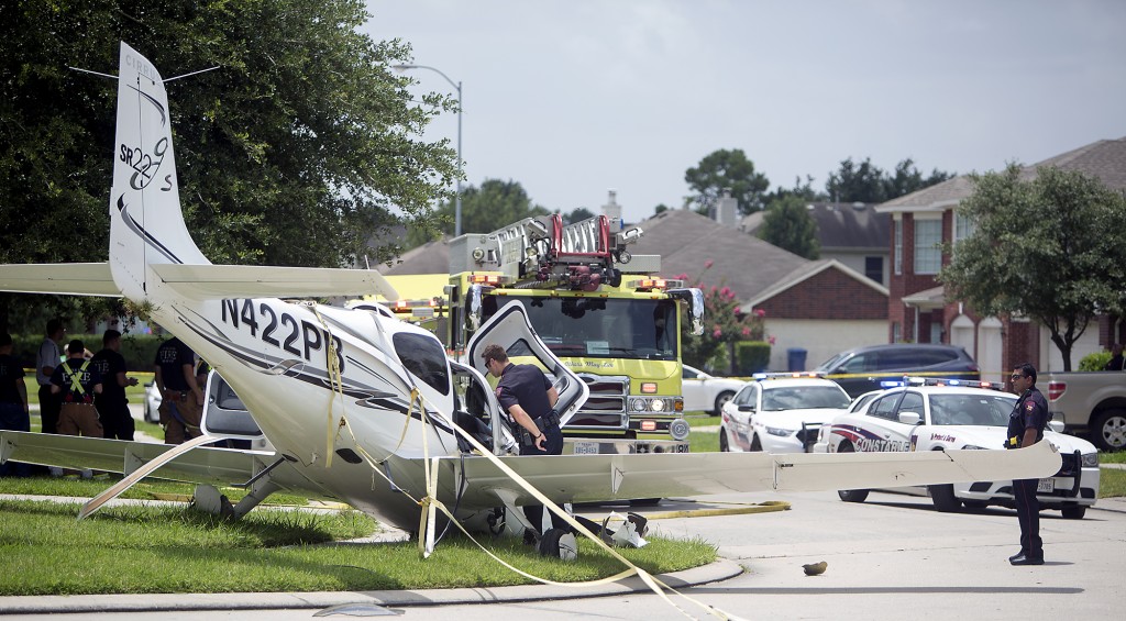
In July, a Cirrus SR22 suffered an engine failure in Houston after departing KIAH.  The CAPS system was deployed and the airplane came to rest in a neighborhood on the north side of Houston.  This makes CAPS save number 53 for Cirrus and no fatalities.  The initial NTSB report is below.

N422PB CAPS

14 CFR Part 91: General Aviation
Accident occurred Tuesday, July 07, 2015 in Houston, TX
Aircraft: CIRRUS DESIGN CORP SR22, registration: N422PB
Injuries: 2 Minor.
This is preliminary information, subject to change, and may contain errors. Any errors in this report will be corrected when the final report has been completed. NTSB investigators may not have traveled in support of this investigation and used data provided by various sources to prepare this aircraft accident report.

On July 7, 2015, about 1137 central daylight time, a Cirrus SR-22 single-engine airplane, N422PB, descended under the canopy of the cirrus airframe parachute system (CAPS) and landed in a residential neighborhood at Houston, Texas. The pilot and passenger sustained minor injuries, and the airplane was substantially damaged. The airplane was registered to and operated by AIRCCS, LLC; Humble, Texas, as a 14 Code of Federal Regulations Part 91 business flight. Day visual meteorological conditions (VMC) prevailed and a flight plan had not been filed. The airplane departed George Bush Intercontinental/Houston Airport (IAH), Houston, Texas, at 1133 and was destined for Austin Bergstrom International Airport (AUS), Austin, Texas.

The pilot reported that during initial climb, he noticed the engine temperatures began increasing and he reduced power in an attempt to lower the engine temperatures. When the airplane was about 900 feet above ground level (agl) the engine began detonating, and soon after there was a complete loss of engine power. With no suitable forced landing areas the pilot deployed the CAPS ballistic parachute system and the airplane impacted terrain and came to rest upright next to a residence.

An initial on-scene wreckage examination showed there was adequate fuel on-board. At the facility where the airplane had most recently been refueled, refueling unit records and a review of security camera video showed that the airplane had been refueled with aviation gasoline and not with jet fuel. Postaccident fuel quality checks of that fuel facility were satisfactory.

The wreckage was moved to a different location and will be further examined. Several avionics components containing non-volatile memory (NVM), including engine performance data, will then be removed from the wreckage for examination and an extraction of useful data is expected.

At 1053 the Automated Surface Observation System at IAH reported wind from 160 degrees at 15 knots gusting to 20 knots, visibility 10 miles, scattered clouds at 3,000 feet agl, broken clouds at 25,000 feet agl, temperature 31 degrees Celsius (C), dew point 24 degrees C, and an altimeter setting of 30.03 inches of Mercury.

Embraer Legacy 450

0 Comments

Brazilian manufacturer Embraer recently received FAA certification for it’s “mid-light” Legacy 450.  Capable of Mach .83 and a 2,500 mile range, this is one sweet airplane.  Embraer designers gave passengers headroom as the cabin stretches up to 6 feet in height down the center.  Complete with fly by wire controls and a full glass cockpit configuration, Embraer did a wonderful job with this airplane.  The club seats even fold down to a bed!

The airplane’s list price is $16.5 million.  To learn more about the Legacy 450, visit Embraer’s website.

Embraer Legacy 450

Flight Watch to be Discontinued

0 Comments

The FAA has decided to discontinue the dedicated En Route Flight Advisory (EFAS or Flight Watch) frequency 122.0.  The effective date will be September 24th, but Flight Service will continue to monitor the frequency for an additional six months to direct pilots to Flight Service Station frequencies.

EFAS services will still be provided by Flight Service, though, on the published Flight Service Station frequencies (and 122.2).

To me, this makes some sense.  In the past, if I accidentally contacted Flight Service on one of their frequencies to issue a pilot report or get a weather update, they would send me over to Flight Watch on 122.0.  More than likely, the Flight Watch operator was sitting right next to the Flight Service operator, but I had to flip frequencies.  This will help alleviate some confusion for pilots.

The deactivation of Flight Watch had been coming for years since the advent of Foreflight and other iPad and tablet apps giving pilots much easier access to weather, both in flight and on the ground.  With Nexrad and Stratus, there isn’t much need for Flight Watch anymore (though you still can’t file a PIREP over the XM Weather!).

For more information, check out AOPA’s website.

Selecting the Proper Altitude

0 Comments

One of the first questions a student pilot asks me when starting the cross country portion of his or her training is, how do I know what altitude is best for my flight?  This is a good question, because without taking certain aspects of the flight into account, it’s really just a crap shoot when selecting an altitude.  Craps and flying don’t mix, so let’s take a look at a few considerations when selecting an altitude.

Sky Coverage

Sky coverage has several subcategories when it comes to selecting an altitude.  First is how high are the bases?  Is it IFR (VFR pilots would be grounded), marginal VFR (1,000 AGL to 3,000 AGL ceiling), or good VFR (above 3,000 AGL ceiling)?  If the cloud deck is only 2,500 feet off the ground, then VFR pilots are limited to either 1,000 AGL to 2,000 AGL.  This is an excellent segue into why VFR pilots shouldn’t scud run!

Scattered Clouds

Second, what kind of cloud deck is it?  Is it an actual ceiling (broken or overcast), or is it a scattered layer?  Few or scattered layers usually allow VFR pilots to find a hole to get higher to some smoother air, making the flight more pleasant.  VFR pilots, always make sure to check the destination weather as it could be scattered where you are departing from, but it might be broken or overcast where you are arriving.

Last, how high are the tops of the clouds?  Pilots can only get this information in the planning stage from the area forecast or from pilot reports, so most of the time, it’s not very precise information.  If the tops are at 10,000 feet and the pilot is flying a 172 on a 30 mile trip, it doesn’t make much sense to get on top of the clouds.

Terrain and Obstacles

Terrain goes hand in hand with sky coverage.  If there are low clouds and high terrain, that doesn’t bode well for trying to stay VFR and not hitting anything.  Obstacles need to be taken into account too, as there are some pretty tall radio towers that can stretch up into a 1,500-2,000 AGL deck of clouds.

Winds Aloft

Winds Aloft

Once the sky coverage and terrain have been considered, it’s time to look at the winds aloft.  Tailwinds are preferred, but, sometimes, a headwind is the only option.  After taking the clouds and terrain into account, this narrows down your altitude to a handful of options.  The winds aloft will further narrow it down.

Aircraft Performance

Once you have two or three altitudes in mind, taking a look at the performance charts for your airplane will help nail down that final altitude.  Pull out the POH, compare fuel burn and cruise speed, and you’ll have your altitude selected.

Skyvector Has a New Look

0 Comments

Skyvector has changed it’s look.  The aeronautical chart website is now offering flight plan filing capability. In order to gain the ability to file flight plans, the user has to form an account first.

Personally, I really liked how Skyvector had a simple interface before they changed.  As an instructor, a lot of times, I go to multiple airports on one flight.  It was really nice to just plug in airport IDs to check distances and heading information on Skyvector.  The new format is a little clunky as the website has made it a little more difficult to do what it did best before.

Did the aviation community need another venue to file flight plans?  Not with Foreflight, Garmin Pilot, and WingXPro leading the way in the app market.  Skyvector was smart in not trying to develop another app to compete with the big boys.

Will the new Skyvector last?  We’ll see.  I’m hoping they’ll go back to the way they used to be, but we’ll see. I may use it enough to come around to liking it.