Skyvector has changed it’s look. The aeronautical chart website is now offering flight plan filing capability. In order to gain the ability to file flight plans, the user has to form an account first.
Personally, I really liked how Skyvector had a simple interface before they changed. As an instructor, a lot of times, I go to multiple airports on one flight. It was really nice to just plug in airport IDs to check distances and heading information on Skyvector. The new format is a little clunky as the website has made it a little more difficult to do what it did best before.
Did the aviation community need another venue to file flight plans? Not with Foreflight, Garmin Pilot, and WingXPro leading the way in the app market. Skyvector was smart in not trying to develop another app to compete with the big boys.
Will the new Skyvector last? We’ll see. I’m hoping they’ll go back to the way they used to be, but we’ll see. I may use it enough to come around to liking it.
L-3 has jumped into the ADS-B transponder game with their Lynx line of products. Aircraft owners have a myriad of options with the Lynx line, from simply becoming ADS-B compliant with the NGT-1000 ($2,100, with ADS-B out that works with the GTX 327 and GTX 330), or going all in with the NGT-9000 touch screen transponder complete with ADS-B In, a traffic screen and NEXRAD ($6,800).
The NGT 1000/2000/2500 line works with the existing transponder in the airplane (as long as it’s a Garmin GTX 327 or 330). The 2000 gives ADS-B In capability, allowing the pilot to access NEXRAD and traffic, plus has a Wifi source to broadcast all the information to an iPad. The 2500 includes all of that, plus gives the pilot MFD capability as well. An optional control panel is available if the airplane is not equipped with one of the aforementioned Garmin transponders.
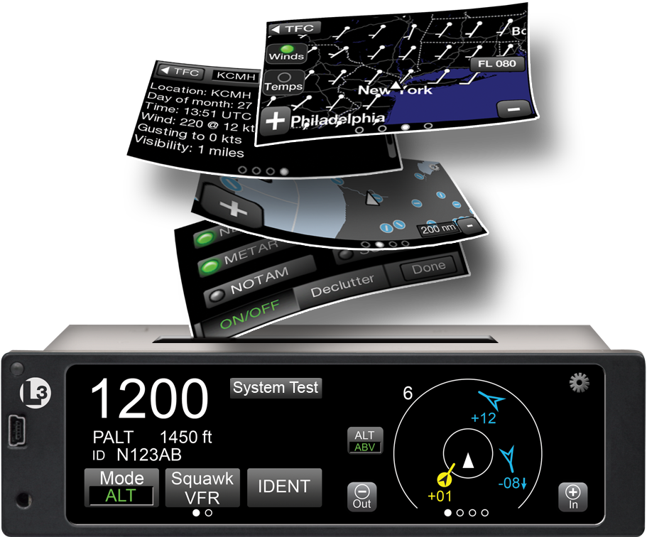
The L-3 Lynx NGT-9000 is an actual transponder replacement. It is a touch screen device that has a multitude of ADS-B features that, quite frankly, are really cool on a transponder. The ADS-B traffic is displayed on the unit itself and can also be sent, via the optional Wifi connection, to an iPad on the WingXPro or SkyRadar apps. The optional L-3 NextGen Active Traffic can also be installed to receive traffic callouts (this does not include resolution advisories). Already have SkyWatch? The L-3 Lynx can use the equipment.
The L-3 Lynx NGT-9000 is also capable of displaying NEXRAD as well as METARs, TAFs, NOTAMs, and TFRs and a myriad of other weather products, all on it’s moving map. It seems that L-3 has taken the transponder and turned it into something awesome.
To read more about the L-3 Lynx line of transponders, you can visit their website.
L-3 has jumped into the ADS-B transponder game with their Lynx line of products. Aircraft owners have a myriad of options with the Lynx line, from simply becoming ADS-B compliant with the NGT-1000 ($2,100, with ADS-B out that works with the GTX 327 and GTX 330), or going all in with the NGT-9000 touch screen…
I’m a big fan of having my Foreflight map always match up exactly with the way I am flying. Having a Flight Stream in the airplane helps a lot with that as it always prompts me to load the new flight plan from the GPS into my Foreflight map. When I load an approach in the GPS flight plan, Foreflight will put it into my Foreflight flight plan via the Flight Stream.
The problem I run into on Foreflight is when there is a published hold at the Initial Approach Fix (IAF), but ATC has told me to fly the straight in approach and skip the hold. Up until recently, I didn’t think there was a way to set up a straight in approach on Foreflight, so I just settled for the hold staying on there.
Not anymore! There is a simple trick that I discovered that allows you to remove the hold from the Foreflight flight plan. Here’s how to do it.
Load the Approach
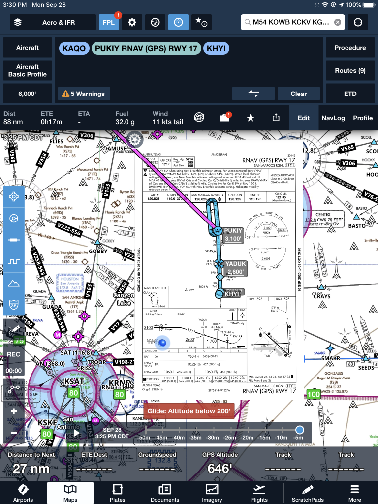
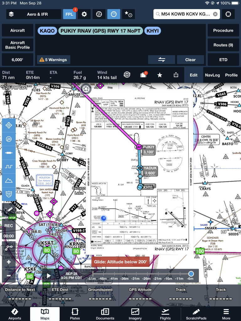
The first step is still to load the approach into your Foreflight flight plan on the Map page. In this scenario, we are flying from KAQO, the Llano Airport, to KHYI, the San Marcos Airport. Austin Approach has told us to expect the straight in RNAV 17 KHYI via PUKIY. So, on Foreflight, we have KAQO and KHYI in our flight plan. Then, I tap the Procedures button on the upper right hand corner of the screen. I then tap Approach, then RNAV 17 KHYI. Then I select my transition.
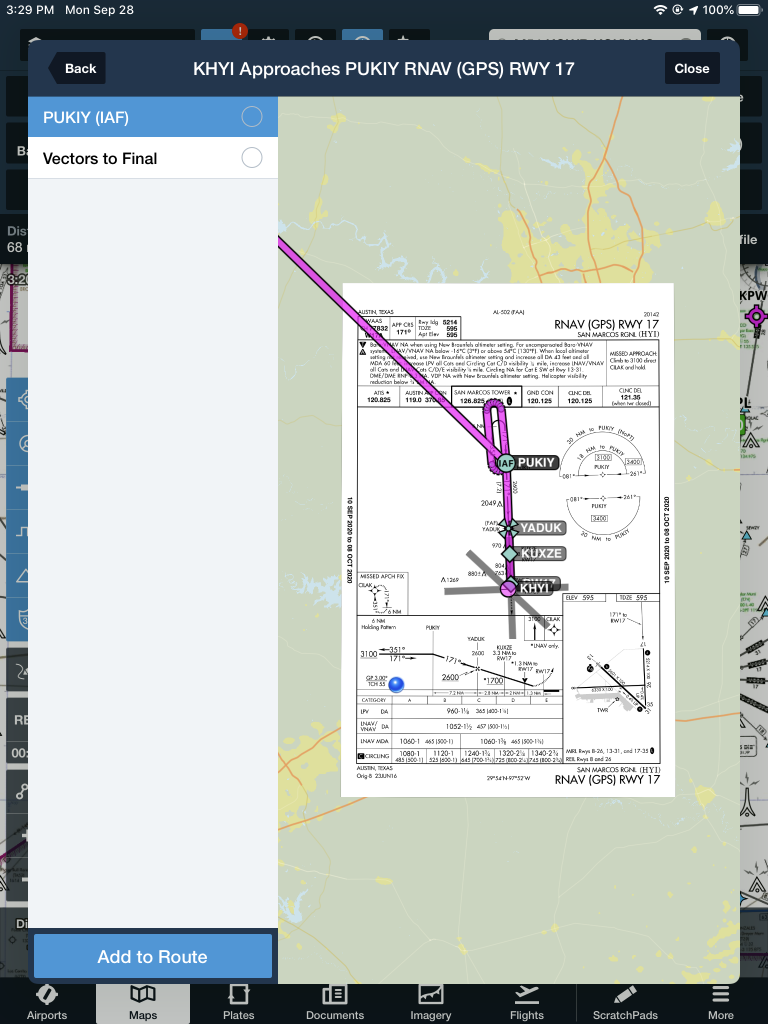
The options given are either PUKIY with the hold, seen below;
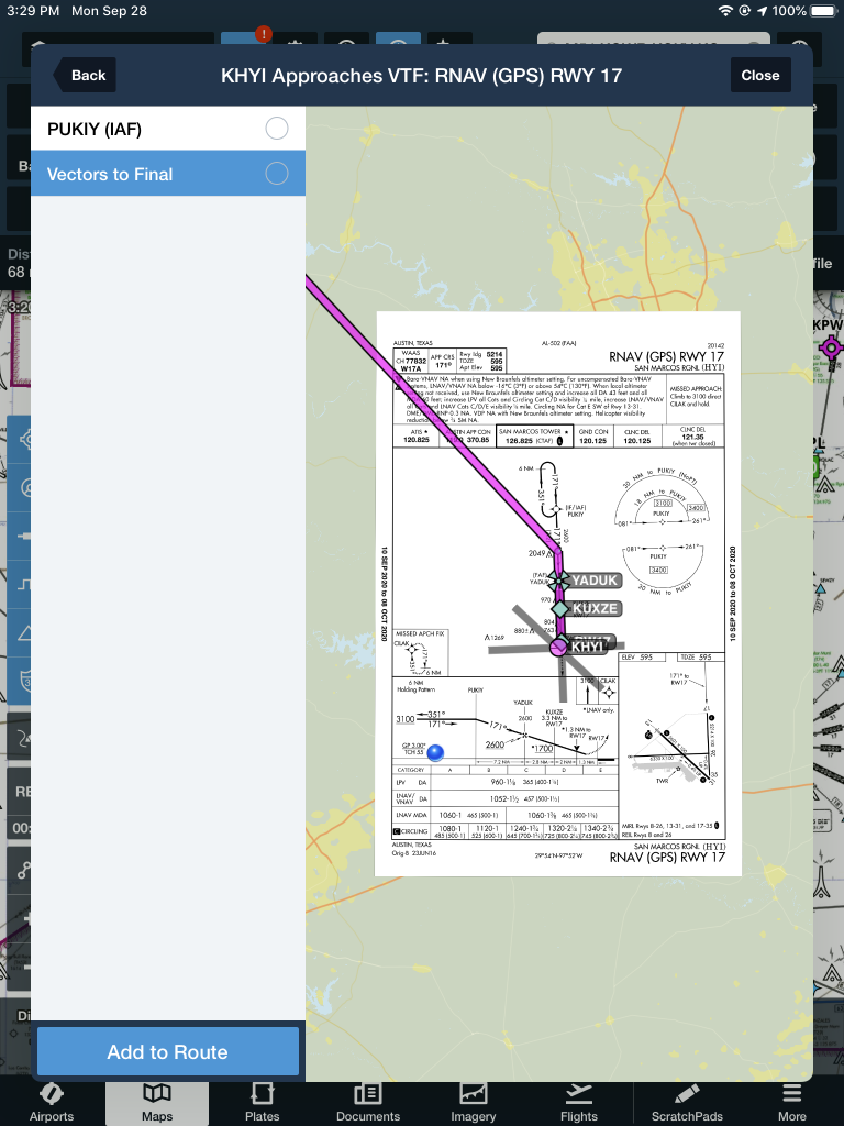
Or Vectors to Final, which lines me up inside of PUKIY. Neither of these are what I want.
But, to get this to work, I select PUKIY, then tap add to route. Now we have our approach loaded into our flight plan.
Removing the Hold
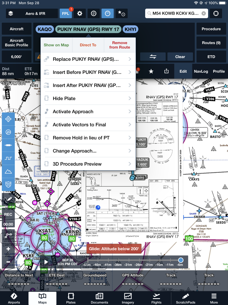
The RNAV 17 is now in the Foreflight flight plan, but the hold is displayed at PUKIY. To remove the hold, the first step is to tap the approach in green and a menu pops up.
The 7th option down is “Remove Hold in lieu of PT.” Eureka! Tap that, then the approach is displayed without the hold. Houston, we have success! It even says “NoPT” in the flight plan.
I’m a big fan of having my Foreflight map always match up exactly with the way I am flying. Having a Flight Stream in the airplane helps a lot with that as it always prompts me to load the new flight plan from the GPS into my Foreflight map. When I load an approach in…
The Garmin G1000/Perspective combined with the Garmin GFC 700 Autopilot can be a great tool in descent planning. When you want to end up at pattern altitude a certain distance from the airport or you get a clearance to cross a fix at a certain altitude, Garmin VNV is a great tool. Here’s how to use it.
VFR Garmin VNV Use
Let’s say you want to end up at pattern altitude 3nm from your destination, but you don’t want to descend down into the bumps before you have to. Here’s how to set it up:
Go to the Flight Plan page on the MFD
Press the ATK OFST soft key on the bottom of the MFD. It stands for Along Track Offset, which, in laymen’s terms, means you are setting a point along your track a certain distance from your destination. In this case, it will be 3nm
Input the distance using either the keypad or the small FMS knob and press enter
Select the altitude you want to be at (in this case pattern altitude) and press enter
You will see a point 3nm before you destination appear on your magenta line and a Top Of Descent (TOD) appear where you need to start your descent
1 minute before the Top Of Descent, an indicator will appear next to your altimeter
To have the GFC 700 Autopilot fly the descent for you, you have to do two things
Set the Altitude bug for the desired altitude
Press VNV on the autopilot
All you have to do now is manage power
IFR Garmin VNV Use
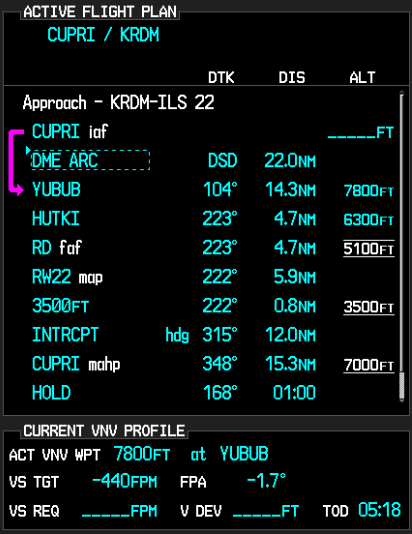
Let’s say you are told to cross a fix at a specific altitude. Here’s how to use Garmin VNV to plan it out.
Go to the Flight Plan page on the MFD
Turn the cursor on and highlight the altitude blank next to the fix in the flight plan
Input the desired altitude
You will see a Top Of Descent (TOD) point appear along your course where you need to start your descent
1 minute before the Top Of Descent, an indicator will appear next to your altimeter
To have the GFC 700 Autopilot fly the descent for you, you have to do two things
Set the Altitude bug for the desired altitude
Press VNV on the autopilot
All you have to do now is manage power
The Garmin G1000/Perspective combined with the Garmin GFC 700 Autopilot can be a great tool in descent planning. When you want to end up at pattern altitude a certain distance from the airport or you get a clearance to cross a fix at a certain altitude, Garmin VNV is a great tool. Here’s how to…
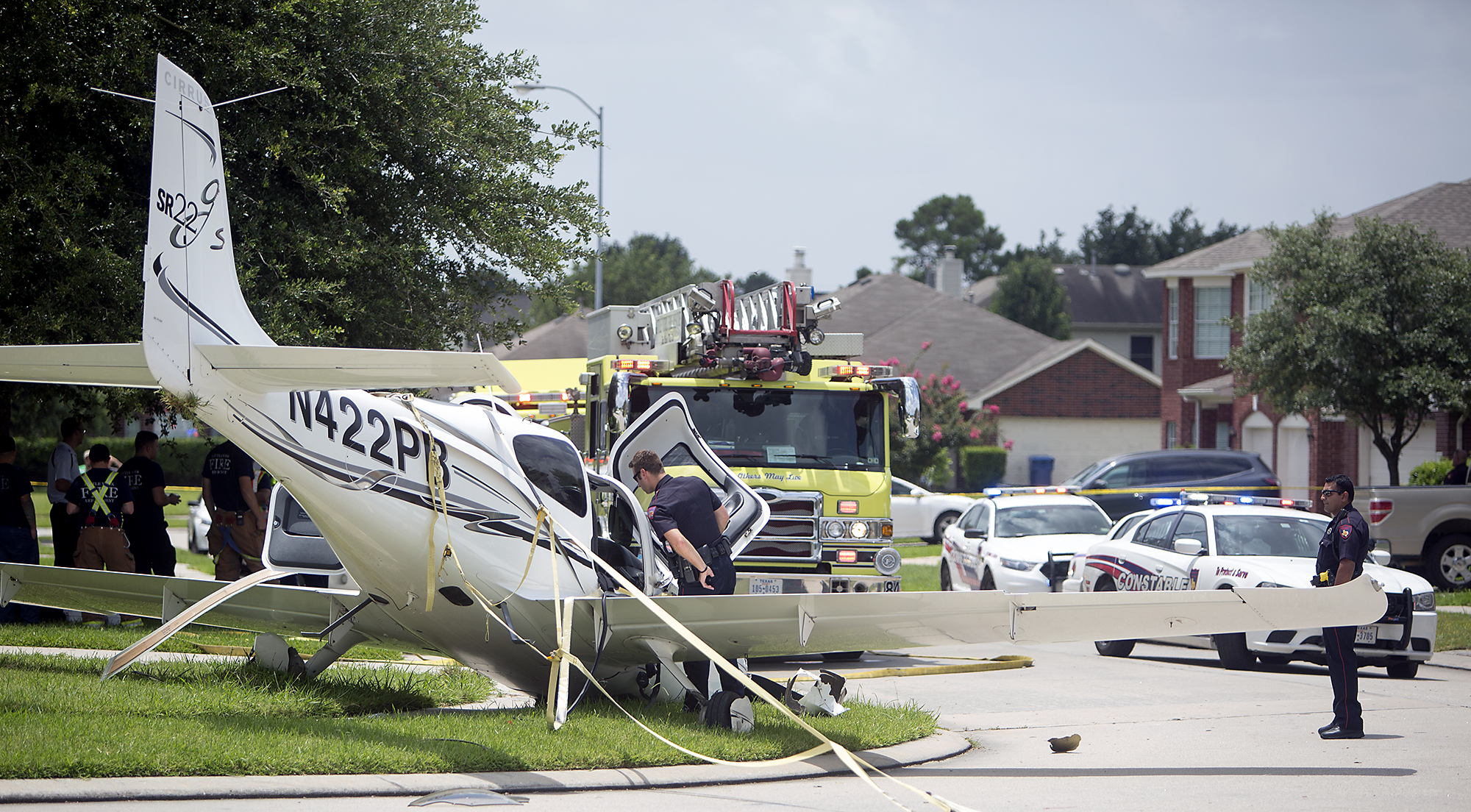
In July, a Cirrus SR22 suffered an engine failure in Houston after departing KIAH. The CAPS system was deployed and the airplane came to rest in a neighborhood on the north side of Houston. This makes CAPS save number 53 for Cirrus and no fatalities. The initial NTSB report is below.
14 CFR Part 91: General Aviation
Accident occurred Tuesday, July 07, 2015 in Houston, TX
Aircraft: CIRRUS DESIGN CORP SR22, registration: N422PB
Injuries: 2 Minor.
This is preliminary information, subject to change, and may contain errors. Any errors in this report will be corrected when the final report has been completed. NTSB investigators may not have traveled in support of this investigation and used data provided by various sources to prepare this aircraft accident report.
On July 7, 2015, about 1137 central daylight time, a Cirrus SR-22 single-engine airplane, N422PB, descended under the canopy of the cirrus airframe parachute system (CAPS) and landed in a residential neighborhood at Houston, Texas. The pilot and passenger sustained minor injuries, and the airplane was substantially damaged. The airplane was registered to and operated by AIRCCS, LLC; Humble, Texas, as a 14 Code of Federal Regulations Part 91 business flight. Day visual meteorological conditions (VMC) prevailed and a flight plan had not been filed. The airplane departed George Bush Intercontinental/Houston Airport (IAH), Houston, Texas, at 1133 and was destined for Austin Bergstrom International Airport (AUS), Austin, Texas.
The pilot reported that during initial climb, he noticed the engine temperatures began increasing and he reduced power in an attempt to lower the engine temperatures. When the airplane was about 900 feet above ground level (agl) the engine began detonating, and soon after there was a complete loss of engine power. With no suitable forced landing areas the pilot deployed the CAPS ballistic parachute system and the airplane impacted terrain and came to rest upright next to a residence.
An initial on-scene wreckage examination showed there was adequate fuel on-board. At the facility where the airplane had most recently been refueled, refueling unit records and a review of security camera video showed that the airplane had been refueled with aviation gasoline and not with jet fuel. Postaccident fuel quality checks of that fuel facility were satisfactory.
The wreckage was moved to a different location and will be further examined. Several avionics components containing non-volatile memory (NVM), including engine performance data, will then be removed from the wreckage for examination and an extraction of useful data is expected.
At 1053 the Automated Surface Observation System at IAH reported wind from 160 degrees at 15 knots gusting to 20 knots, visibility 10 miles, scattered clouds at 3,000 feet agl, broken clouds at 25,000 feet agl, temperature 31 degrees Celsius (C), dew point 24 degrees C, and an altimeter setting of 30.03 inches of Mercury.
In July, a Cirrus SR22 suffered an engine failure in Houston after departing KIAH. The CAPS system was deployed and the airplane came to rest in a neighborhood on the north side of Houston. This makes CAPS save number 53 for Cirrus and no fatalities. The initial NTSB report is below. 14 CFR Part 91:…
I got a call today from a friend asking me about oxygen requirements. That got my brain pondering about the different items the FAA would like all pilots to know. I did a little refreshing and found several other tidbits directly from the FAA that I thought worth sharing. No matter what you’re flying, I think these apply to all of us.
First off, what are our general oxygen requirements? If you jump on over to the FAR’s and take a look at 91.211 you’ll see:
1. At cabin pressure altitudes above 12,500ft MSL to 14,000ft MSL, pilots
required to use oxygen unless the segment is less than 30 minutes of flight.
2. At cabin pressure altitudes above 14,000ft MSL, the crew is required to use
oxygen.
3. At cabin pressure altitudes above 15,000ft MSL, each occupant must be provided the use of oxygen. This doesn’t necessarily mean they have to use it.
Things get a little more in depth when you get to pressurized aircraft.
These requirements are also listed in 91.211:
1. If you’re flying above Flight Level 250, a 10 minute supply of oxygen is
required for each person onboard.
2. If you’re flying above Flight Level 350-410, and one pilot leaves their seat, the other pilot will be required to wear an oxygen mask, unless both seats are equipped with quick-donning oxygen masks.
There are three basic components to any oxygen system in an aircraft: the storage system, the delivery system, and the mask or cannula. First, there are several types of storage systems.
Gaseous aviators breathing oxygen is the first. This is the standard green tank that everyone is familiar with. There are two types of tanks. Either the high- pressure with 1800-2200 psi or the low pressure tank with 400-450 psi. The major issue with these and General Aviation aircraft is weight. Some of these tanks can get bulky and heavy and therefore don’t work for everyone.
Liquid aviators breathing oxygen or LOX is another form of storage. The major advantage of LOX is that it has a 900 to 1 expansion ratio, meaning that 1 liter of liquid oxygen can be expanded into 900 gaseous liters of Aviators Breathing Oxygen. The disadvantages of LOX are they are extremely volatile and have to be stored at -197F. If it comes in contact with exposed skin, severe frost bite can occur.
Sodium chlorate candles or oxygen generators have a weight advantage like LOX. They’re essentially a canister that when activated mix sodium chloride and iron powder and produce oxygen. They general have a 600 to 1 expansion ratio, which goes back to the weight savings. However, once these are started they are very hard to stop. Another disadvantage is these devices produce a fair amount of heat, so proper precautions need to be taken.
Next are the delivery systems. The main systems are Continuous Flow, Diluter Demand, and Pressure Demand. Continuous Flow, is exactly as it sounds. The oxygen is allowed to flow continuously from the tank to the user. The benefits of continuous flow are you don’t need a complicated mask or regulator. The downside to this system is since it continuously pumps oxygen, you’re wasting oxygen when you exhale. Most of continuous flow systems are used on aircraft that generally fly below 28,000 feet.
Diluter Demand was designed to fix the negative of the Continuous Flow systems. Diluter Demand only sends oxygen to the user when the user inhales. The system also allows cabin air to be introduced in, sending the perfect mixture of oxygen to the user when needed. These systems are very efficient and generally tend to be used up to 40,000 feet.
Pressure Demand is designed to essentially “over inflate” the users lungs. This will basically pressurize the the users lugs and allow the user to fly above 40,000 feet. This is needed at flights above FL400 because 100% oxygen without positive pressure will not suffice.
The final portion of the oxygen system is the mask or cannula. Nasal cannulas generally are more comfortable and are regulated to 18,000 feet service altitude. Masks come in a couple different variants. From re-breathers to quick-donning, most masks accomplish the same task with a few small differences. Quick-donning must be able to be put on within five seconds and are rated up to FL400.
Since that was a lot of information, what does all of it mean to you? Most fair weather flyers will never run into any of this. However, the high performance owner/operator will run into oxygen use situations a fair amount. Taking the family up to Colorado on a ski trip, jumping up to 12,500 feet to get above some weather, or flying above 5,000 feet at night on a long xc are all situations where you may want to have oxygen on board.
If you are planning on doing any of this type of flying or are currently doing these types of flights, training is a must. If you’ve never been in an altitude chamber, I would highly recommend it. In college, I went with a group to Oklahoma City to the FAA’s headquarters where they hold a class on Hypoxia and High Altitude flying. It’s very informative to be in the chamber as it simulates being oxygen deprived. You get to see how you’ll react and what kind of symptoms you’ll have when in a loss of oxygen situation. Each person has different symptoms, so it’s important to see how you will react.
It’s also good to fly with an experienced instructor. Finding an instructor who will allow you to learn in a safe environment is worth its weight in gold.
Ryne Bergren is currently a First Officer with Mesa Airlines in the CRJ 900. Ryne has experience in many different areas of aviation, from corporate to airlines to teaching to ferrying across the Atlantic Ocean. His passion is for all things that travel across the big blue sky.
I got a call today from a friend asking me about oxygen requirements. That got my brain pondering about the different items the FAA would like all pilots to know. I did a little refreshing and found several other tidbits directly from the FAA that I thought worth sharing. No matter what you’re flying, I…
The 2020 Texas Top Aviation Santa Fe Golf Fly In has been re-scheduled due to the COVID-19 pandemic and quarantine. The new date is September 3rd-5th at the Santa Fe Buffalo Thunder Resort and Towa Golf Club.
For more information on the event and to register, please click here.
The 2020 Texas Top Aviation Santa Fe Golf Fly In has been re-scheduled due to the COVID-19 pandemic and quarantine. The new date is September 3rd-5th at the Santa Fe Buffalo Thunder Resort and Towa Golf Club. For more information on the event and to register, please click here.