Cirrus Autopilot Check

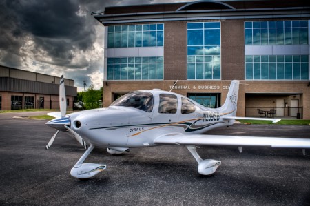
In the Pre-Takeoff Checklist for any Cirrus aircraft, it calls for pilots to perform a Cirrus Autopilot Check.  It is prudent to check the autopilot before your flight to ensure that all aspects of the autopilot are working properly.  The only problem is, the checklist doesn’t spell out how to perform the Cirrus Autopilot Check.  You would have to go to the POH for the airplane, which is usually in the back seat or a bag somewhere and therefore hard to get to, in order to find the procedure.

The procedure for checking the autopilot is slightly different depending on what autopilot is in your airplane.  The procedures for all three are below.

S-TEC 55x

  • Sync the heading bug to your current heading
  • Activate heading mode on the autopilot
  • Twist the heading bug left and right to ensure the ailerons move left and right
  • Sync the heading bug to your current heading
  • Activate vertical speed mode on the autopilot
  • Move the vertical speed bug (or the vertical speed on the altitude pre-selector if you have a steam gauge Cirrus) up and down to ensure the elevator moves accordingly
  • Ensure you can overpower the autopilot
  • Press the autopilot disconnect switch to ensure the autopilot shuts off


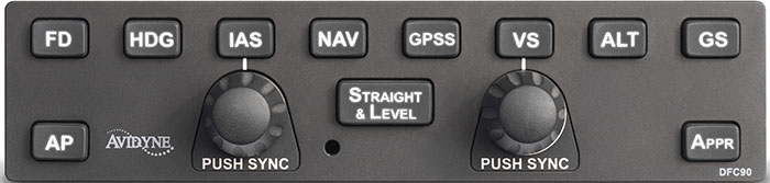
Avidyne DFC 90

  • Press the AP button to activate the autopilot
  • Ensure AP, ROLL, and PITCH Annunciations are depicted in green on the top of the PFD
  • Set the heading bug 90 degrees from the current heading
  • Press the HDG button on the autopilot
  • Ensure the ailerons are moving in the proper direction and HDG is annunciated on the top of the PFD
  • Ensure you can overpower the autopilot
  • Press the autopilot disconnect switch on the stick and ensure the autopilot has disconnected


DFC90

Garmin GFC 700

  • Press the AP button to activate the autopilot
  • Ensure you can overpower the autopilot
  • Press the autopilot disconnect switch on the stick to ensure the autopilot has disconnected

Similar Posts

  • Drones: A Brief History

    Drones; these technological wonders have, seemingly, come out of nowhere over the course of a few years. Although they bring with them the promise of convenience and fun, they have also brought problems and uncertainty for the government, general public, and, specifically, the aviation community. But, where did drones come from and are they really something to be worried about? Let’s take a look at Unmanned Aerial Systems (UAS) and hopefully put to bed some of the concerns which seem to be following them around.

    It shouldn’t come as a surprise to anyone when I say that drones have recently become overwhelmingly popular. The military, businesses, and hobbyists are increasingly utilizing them for all kinds of purposes, which range from enemy surveillance to package delivery. Drone pilots are in high demand and several aviation universities are even offering majors designed to produce graduates which specialize in UAVs (Unmanned Aerial Vehicles).

    Drones are relatively new to the landscape of unmanned flying machines. Although model airplanes have been popular since the dawn of aviation, the first “drones” didn’t start becoming commercially available until a few years ago. As electronic technology advanced, so did model aviation. Models became more and more sophisticated and could be flown remotely as long as they remained within sight of the person flying it.

    It wasn’t until about 3 or 4 years ago that the technology became available to develop drones. This is due to the need for very small and light electric motors, batteries, and stabilization systems. Once these started to become popular, it didn’t take long for drones to become bigger, cheaper, and completely automated.

    It is important to note that there is a difference between drones and conventional model airplanes and helicopters. Drones are defined most simply as an unmanned vehicle which can be operated without user input from the ground. Conventional model aircraft can take all shapes and sizes, but must be operated within line of sight from the operator; as they have no ability to fly, takeoff, land, or navigate without input via a radio transmitter. So, if you happen to see a model aircraft flying, don’t assume automatically that it is a drone. Most of the time, model airplanes, helicopters and even drones are being flown safely and legally.

    Generally, a drone is designed with several arms which come off of a central body. Each of the “arms” typically has a motor with a rotor mounted on it to provide lift while the main body is home to the radio equipment, landing skids and camera gear. If you see a model flying that looks like a conventional airplane or helicopter, odds are it isn’t a drone. Most likely it is being flown recreationally by someone nearby.

    Historically, model airplanes and helicopters have been difficult to learn to fly. Before the times of pre-built foam airplanes and ready to fly drones, a modeler had to build their flying machine and find someone to teach them how to fly it. (Otherwise, they would likely only get one short flight). New modelers would be directed toward the local model flying club and would get plugged in with a group of established fliers who could outline the rules for model aircraft as well as get them up in the air safely.


    However, because most everything is purchased online in today’s market, drones are bought and flown by enthusiasts who have not been taught the rules, safety protocols, and procedures necessary to safely operate their new kits. In addition, the drones incredible stability and ability to be flown without any skill means that anyone with great enough funds and an equally great lack of common sense can buy a model and program it to fly over any location they choose. Unfortunately, sometimes that includes places which cause problems.

    Andrew Robinson is a 135 Charter Pilot and flight instructor who lives with his wife and 2 daughters in Pennsylvania.  He flies Pilatus PC-12s and instructs in Beechcraft Bonanzas.

  • Garmin GFC 600 Autopilot Certified for the Piper Meridian

    In the fall of 2021, Garmin announced the long awaited confirmation that the Garmin GFC 600 autopilot is now certified for the Piper Meridian. The Garmin GFC 600 autopilot has been certified for all other types of the Piper PA46 line of aircraft, but the Meridian was last in line. The airplane has to have been manufactured prior to 2009 and have Avidyne avionics, Meggitt, or have been retrofitted with a Garmin G500 (no G1000 aircraft since those already have the GFC 700 autopilot).

    The Garmin GFC 600 autopilot is the ultimate digital autopilot. The integration with the Garmin G500, GTN 750 and GTN 650 units is a beautiful thing. The autopilot communicates with all the heading and altitude bugs, flies approaches smoothly, and even has a level button.

    In the latest technological marvel from Garmin, Garmin Safe Glide, the GFC 600 autopilot is critical in reducing pilot workload in an engine failure situation. It flies the airplane for you and takes you to the nearest airport, reducing the stress and allowing the pilot to troubleshoot the situation.

    Texas Top Aviation recommends Abilene Aero in Abilene, Texas for any and all avionics installs. They have worked with several of our customers in the last year, are extremely knowledgable and do excellent work. Call them for a quote on a new Garmin GFC 600 autopilot in your Piper Meridian.

  • Piper PA46 Partnership in San Antonio

    A Piper PA46 partnership is being formed in the San Antonio area. Two to three partners are being sought to purchase either a Piper PA46-310P Malibu or a ’90s model Piper PA46-350P Mirage.

    The Piper PA46 Malibu is the original Piper PA46 airframe. It is equipped with a Continental TSIO 520, 310HP engine (though many have been upgraded to the Continental TSIO 550C engine, which is a great upgrade), is complex, and pressurized (the best feature about the airplane!). The six seat airframe travels around 185-190 KTAS at FL200 on 16-17 GPH, giving an incredible range with 120 gallons of fuel.

    The Piper Mirage is what Piper designated the PA46 when it switch to the Lycoming TIO 540 350HP engine in 1989. The airframe remained the same, but the engine eeks out a few more KTAS at 22-25 GPH depending on how high the cruise altitude is.

    Both the Piper Malibu and the ’90s model Mirage are equipped with the KFC 150 autopilot. A lot of the Piper PA46 airframes still have a Garmin 530W/430W or dual 430Ws, but a large number have been upgraded to the Garmin GTN 750/650, while a few have opted for the Avidyne IFD 540/440 GPS units. There are a fair number still with steam gauges, while some have upgraded to Aspen units or the Garmin G500 or G500TXi.

    If you are located in the San Antonio area and interested in a 3-4 way partnership on a Piper PA46, please Contact Us. The purchase price will be between $300,000-$450,000, so only interested parties that can afford a budget of $100,000-$150,000 please.

    The plane will be based at Stinson Field (KSSF) or New Braunfels (KBAZ).

  • A Complex Clearance?

    I was flying in the Rio Grande Valley in south Texas a few weeks ago and heard an IFR clearance given to a King Air that pricked my ears up.  It was a clearance from CRP to LRD, but the routing was one you don’t hear too often anymore.  Because of active military airspace, the routing was via a radial and DME off the CRP VOR (so a point defined by the radial and DME) to another radial and DME point off the LRD VOR.

    It took me a second to think about how to do this the easiest (without setting up the VOR and watching the DME).  After a moment’s thought, it’s actually a snap with the G1000.  You create 2 user waypoints, one for each Radial/DME spot, then put those 2 user waypoints in your Flight Plan.

    Here’s how.

    Step 1

    Using the big knob, go to the Waypoint chapter.  Once there, scroll down to the User Waypoint page using the small knob.

    Step 2

    Press the New soft key.  If you want to name the waypoint something specific, you can do that at the top of the page.  If not, it will default to something like VOR 1 or VOR 2.

    Step 3

    Under Waypoint Type, use the small knob to select RAD/DIS (stands for Radial/Distance).

    Step 4

    Under Reference Waypoints, again using the small knob (or your keypad), type or dial in the VOR identifier, the radial from that VOR, and the DME distance.  Press enter and you are done.

    Once you have both User Waypoints created, then just put them in your flight plan (if you forget what you named them, you can just go back to the User Waypoint page), and off you go.

  • Flight Training Deemed Essential Business

    There have been lots of changes in all parts of our lives with the coming of COVID-19. All of our lives have been affected in one way or another. We hope and pray that none of your families have been directly affected by the illness.

    A lot of us have been living under Shelter in Place orders for several weeks now, only going out for groceries and making sure to keep our distance from people. We have to take a different mindset when we go out now. Even meeting new people is different since we can’t shake hands.

    Flying has been an afterthought for a lot of pilots. There have been multiple ATC facilities where controllers have been afflicted with the virus and have had to shut down for hours or days. Airspace can change pretty quickly, going from what we all know as normal, to an ATC-ZERO scenario. This was the case for New York Center several times over the last two weeks.

    There was some uncertainty regarding flight training under the shelter in place orders and Texas Top Aviation has been asked several questions about it over the last week. Yesterday, the Flight School Association of North America (FSANA) announced that flight instruction was indeed an essential business.

    In an article on GeneralAviationNews.com, the website quoted a memorandum of understanding written by attorney George Winton on March 24th. Winton was a senior attorney for the FAA and U.S. Department of Justice, and now operates The Aviation Law Firm in Annapolis, Maryland.

    “This memorandum affirms the statement that…flight training would be included as a critical infrastructure activity. Those engaged in the provision of and receipt of flight training who work to provide enhanced compliance with CDC recommendations for limiting potential COVID-19 exposure and spread would be considered exempt from travel limitations imposed by local authorities.”

    Winton’s memo was sent to the Department of Homeland Security’s Cybersecurity and Infrastructure Security Agency (CISA). In the memo, Winton stated:

    “CISA listed Other Community-Based Government Operations And Essential Functions as follows: Workers who support necessary credentialing, vetting and licensing operations for transportation workers.”

    “The aviation sub-sector stakeholders involved with operation of recreational aircraft and flight schools, who employ Essential Critical Infrastructure Workers from the Transportation Sector, support necessary credentialing, vetting and licensing operations for transportation workers seeking pilot certification by the Federal Aviation Administration. Since CISA intended to be overly inclusive to reflect the diversity of industries, the aviation mode stakeholders understand that essential employees involved with the operation of recreational aircraft and flight schools continue to be identified as Essential Critical Infrastructure Workers from the Transportation Sector. Accordingly, the aviation sub-sector stakeholders who employ Essential Critical Infrastructure Workers from the Transportation Sector will continue to operate recreational aircraft and flight schools, appropriately modified to account for CDC workforce and customer protection guidance, based upon the CISA memorandum dated March 19, 2020.”

    Based on the above guidance, Texas Top Aviation will continue to operate flight training in all of it’s normal capacities, while maintaining vigilance concerning sanitation, cleanliness, and health. Our company will keep it’s customer’s up to date on instructor health and wellness and won’t hesitate to cancel if there is any kind of health concern. We ask our customers to do the same.

    If you are scheduled to train with Texas Top Aviation, please don’t hesitate to contact us with any questions or concerns you might have.

    To read the entire memo from George Winton, you can find it here.


    Concerning the 2020 Texas Top Aviation Santa Fe Golf Fly In scheduled for June 5th-7th, that event is currently being re-scheduled for September 2020. Dates will be announced by the end of April. We look forward to seeing you in Santa Fe in September!

  • Calm Wind Landings

    Some of a pilot’s favorite words are heard on the ATIS:  “Winds, Calm.”  These words set off all sorts of happy bells and hallelujah choruses.  Most pilots spend their lives fighting the winds.  On those rare days when the winds are calm, great happiness ensues.

    Limp Wind Sock

    But, are calm wind landings more complicated then everyone thinks?  Well, they can be if the proper planning doesn’t go into them.

    Let’s think about wind.  We have surface wind and we have winds aloft. Sometimes the surface winds are calm.  When this happens, certain airports have preferred calm wind runways which are supposed to be used in these conditions.  Winds aloft are almost never calm.  95% of the time, there is some kind of wind even 100-200 feet above the surface.

    Here is the question pilot’s face when coming into an airport with calm winds: which runway do I use?  Do I use the calm wind runway?  Do I use the runway that is easiest to enter the pattern for?  Do I use the one with the shortest taxi?

    A lot of technologically advanced aircraft have a wind indicator on the PFD. This tool is often forgotten in calm surface wind conditions.  On the contrary, this is probably the most important tool a pilot can have when figuring out which runway to use when the winds are reported calm.

    Here’s why.  That wind indicator is showing the pilot what the winds aloft are. The winds aloft should determine what runway is going to be used.  If the wind indicator is depicting a south wind, then a south runway should be used.  Even if it is a 5 knot wind at pattern altitude, it’ll still be a headwind coming in on final approach.  If the north facing runway is used, that same 5 knot headwind can blow an airplane halfway down the runway before the ground speed drops off enough for it to land.

    So, the next time you are coming into an airport and the winds are reported calm, take a look at your wind indicator on your PFD when deciding which runway to use.  It’ll probably save a few go arounds!

Leave a Reply

Your email address will not be published. Required fields are marked *